
By: Daniel Eggleston,
Most news about UAVs discusses their use as a military weapon, or is presented in the context of privacy concerns of citizens, or debates about the FAA’s regulation of civilian drones.[1] What isn’t talked about nearly as often is how drones are being implemented in the agricultural industry.[2] Farmers are finding ways to use drones to help increase yields and reduce crop damage.[3] “Worldwide, agriculture is the largest commercial market for unmanned aerial vehicles.”[4]
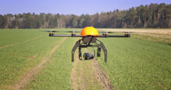
Unmanned aerial vehicles (UAVs) are replacing small aircraft as a practical and efficient way to monitor crops and collect data to optimize crop yield.[5] Crop imaging with UAVs is “. . . also much cheaper than crop imaging with a manned aircraft, which can run $1,000 an hour.”[6] Because FAA regulations require commercial drones to fly at an altitude of 400 feet or less,[7] they aren’t inhibited by clouds like a manned aircraft might be.[8]
Due to recent technological advances, drones have become much more prevalent in non-military settings.[9] This is in part because of the smartphone industry – many components used in smartphones are also used in drones.[10] For example, both contain GPS modules and powerful processors, and both utilize compact cameras.[11] Because of the demand for affordable components in the smartphone industry, drones have also become more affordable.[12] Farmers can buy drones for less than $1,000 apiece.[13]
Software organizes and interprets the information agriculture drones collect.[14] One platform, called DroneDeploy, “provides a suite of mobile and desktop tools that allow drone operators to plan and execute their automated flights, upload imagery collected from the drone’s camera to cloud-based servers to be processed into large area maps, and to analyze the 2D and 3D models.”[15] Maps can then be used to monitor weed locations, yield production, crop canopy closure, and plant population.[16]
“Drones can provide farmers with three types of detailed views.”[17] First, farmers can use aerial images of their crops to detect problems with irrigation, soil variation, and other issues that may not be visible at ground level.[18] Second, drones can utilize infrared and multispectral imagery to capture data that help farmers monitor the health of their crops.[19] Third, drones can survey crops constantly, providing data on demand farmers can use to optimize production.[20]
What’s more, FAA regulations released in August of 2016 make it substantially easier for the general public to use commercial drones.[21] “Previously, drone operators had to apply for special waivers from the FAA – a time-consuming and pricey process – to use UAVs for business.”[22] Now, to operate a commercial drone, one need only be 16 years old and qualify for a flying certificate.[23] As for the drone itself, in order to comply with the FAA it must weigh less than 55 pounds, fly no more than 400 feet in altitude, and not reach speeds exceeding 100 miles per hour.[24] Additionally, drones must be operated during the day and only 30 minutes before sunrise and after sunset, but operators can apply for waivers if they want to fly UAVs in circumstances that do not comply with the above regulations.[25]
The loosening of drone regulations coupled with the availability of affordable UAVs allows farmers to benefit from this emerging technology. [26] And, as the demand for food continues to grow along with the world’s population, the agricultural industry is a ready market for technological innovation. [27] With production yields in mind, “. . . the next revolution in agriculture will almost certainly be driven by the introduction of new precision farming techniques . . ..”[28] Drones are just one way farmers are using tech to better understand how to manage their crops and lower input costs.[29]
[1] See Chris Anderson, Agricultural Drones, MIT Tech. Rev. (Apr. 23, 2014), https://www.technologyreview.com/s/526491/agricultural-drones/.
[2] See id.
[3] See id.
[4] Prachi Patel, Agricultural Drones Are Finally Cleared for Takeoff, IEEE Spectrum (Oct. 19, 2016), http://spectrum.ieee.org/robotics/drones/agriculture-drones-are-finally-cleared-for-takeoff.
[5] See Anderson, supra note 1.
[6] Id.
[7] See id.
[8] See id.
[9] See Anderson, supra note 1.
[10] See Patel, supra note 4.
[11] See id.
[12] See id.
[13] See id.
[14] See Jose Antunes, GeoTiffs and Drone Mapping Data: A Unique Solution for Agriculture, Commercial UAV Expo (Nov. 6, 2016), http://www.expouav.com/news/latest/geotiffs-drone-mapping-data-unique-solution-agriculture/.
[15] Id.
[16] See id.
[17] See Anderson, supra note 1.
[18] See id.
[19] See id.
[20] See id.
[21] See Nyshka Chandran, FAA’s new drone laws go into effect Monday, allowing US companies to innovate, CNBC (Aug. 29, 2016), http://www.cnbc.com/2016/08/29/faas-new-drone-laws-go-into-effect-monday-allowing-us-companies-to-innovate.html.
[22] Id.
[23] See id.
[24] See id.
[25] See id.
[26] See Chandran, supra note 11.
[27] See Anderson, supra note 1.
[28] David Murray, Drones lead way in precision agriculture, Great Falls Tribune (Nov. 3, 2016), http://www.greatfallstribune.com/story/news/local/2016/11/03/drones-lead-way-precision-agriculture/93272348/.
[29] See id.
Photo Source:
http://images.atelier.net/sites/default/files/imagecache/scale_crop_587_310/articles/424650/atelier-drones-agriculture.jpg